
Mappa topografica Chatham
Mappa interattiva
Clicca sulla mappa per visualizzare l'altitudine.
A proposito di questa mappa
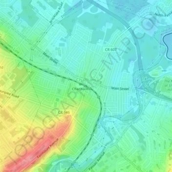
Nome: Mappa topografica Chatham, altitudine, rilievo.
Luogo: Chatham, Morris County, New Jersey, United States (40.72430 -74.39975 40.75521 -74.36307)
Altitudine media: 76 m
Altitudine minima: 51 m
Altitudine massima: 141 m
The Passaic River, which rises at Millington Gorge in Long Hill Township and defines the Great Swamp, flows north along the eastern boundary of Chatham. A good crossing location, identified by Native Americans to early European settlers, figured significantly in the colonial history of the community. Fairmount Avenue ascends Long Hill perpendicularly from Main Street in the contemporary center of town to the highest elevation of the town among the Watchung Mountains. From there, one may see the lights of New York beyond the crest of the ridge hills of Summit and Short Hills. Water from artesian wells is stored at its crest to provide the drinking water for the community.
Altre mappe topografiche
Clicca su una mappa per visualizzarne la topografia, l'altitudine e il rilievo.
Randolph Township
United States > New Jersey > Morris County
Randolph Township, Morris County, New Jersey, 07869, United States
Altitudine media: 247 m
Mount Olive
United States > New Jersey > Morris County
Mount Olive, Morris County, New Jersey, United States
Altitudine media: 280 m
Montville Township
United States > New Jersey > Morris County > Montville Township
Montville Township, Morris County, New Jersey, United States
Altitudine media: 115 m
Parsippany-Troy Hills
United States > New Jersey > Morris County
Parsippany-Troy Hills, Morris County, New Jersey, United States
Altitudine media: 113 m
Rockaway
United States > New Jersey > Morris County
Rockaway, Morris County, New Jersey, United States
Altitudine media: 196 m