
Mappa topografica Abancay
Clicca sulla mappa per visualizzare l'altitudine.
Abancay
Abancay is located at an elevation of 2,377 metres (7,799 ft) above sea level in the southern Peruvian Andes, above the Pachachaca River, and straddles the Marino River. Because of its dry mountain and famous year-round warm weather it is known as "The Eternal Springtime Valley". The nearest cities are Cusco, Chalhuanca and Andahuaylas. Abancay is located at the junction of two important Peruvian roads: the Caminos del Inca Road, an old road dating from Incan times, between the cities of Nazca and Cusco, and the Via de los Libertadores, connecting Ayacucho and Cusco.
A proposito di questa mappa
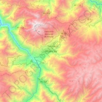
Nome: Mappa topografica Abancay, altitudine, rilievo.
Luogo: Abancay, Province of Abancay, Apurímac, Peru (-13.79735 -73.03887 -13.47735 -72.71887)
Altitudine media: 3’400 m
Altitudine minima: 1’407 m
Altitudine massima: 5’191 m
Altre mappe topografiche
Clicca su una mappa per visualizzarne la topografia, l'altitudine e il rilievo.