
Mappa topografica Fuenlabrada
Mappa interattiva
Clicca sulla mappa per visualizzare l'altitudine.
A proposito di questa mappa
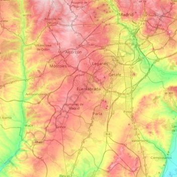
Nome: Mappa topografica Fuenlabrada, altitudine, rilievo.
Altitudine media: 630 m
Altitudine minima: 495 m
Altitudine massima: 741 m
The founding of the village of Fuenlabrada has been tentatively traced to the late 14th century, populated by the dwellers of the nearby settlements of Loranca, Albas and Fregacedos, which had been simultaneously depopulated. The first mention of Fuenlabrada, which by the early 16th century was part of the Land of Madrid, was recorded later in the century, during the reign of Philip II, in the so-called Topographic Relations of Philip II. The village suffered the loss of a quarter of the population in the second half of the 18th century.