
Mappa topografica Laramie
Mappa interattiva
Clicca sulla mappa per visualizzare l'altitudine.
A proposito di questa mappa
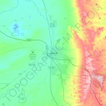
Nome: Mappa topografica Laramie, altitudine, rilievo.
Luogo: Laramie, Albany County, Wyoming, 82070, United States (41.15137 -105.75110 41.47137 -105.43110)
Altitudine media: 2’299 m
Altitudine minima: 2’133 m
Altitudine massima: 2’744 m
Laramie is on a high plain between two mountain ranges, the Snowy Range, about 30 miles (48 km) to the west, and the Laramie Range, 7 miles (11 km) to the east. The city's elevation above sea level is approximately 7,165 feet (2,184 m). The Laramie River runs through Laramie toward its confluence with the North Platte River east of the Laramie Range.