
Fai una donazione
Equipaggiati per la tua prossima avventura:
In qualità di Affiliato Amazon, questo sito riceve una commissione sugli acquisti idonei, senza costi aggiuntivi per l’utente.
Mappa topografica Hawassa
Clicca sulla mappa per visualizzare l'altitudine.
Fai una donazione
Equipaggiati per la tua prossima avventura:
In qualità di Affiliato Amazon, questo sito riceve una commissione sugli acquisti idonei, senza costi aggiuntivi per l’utente.
Hawassa
Hawassa (Amharic: አዋሳ; ʾäwasa, also spelled Awassa or Awasa) known historically as Adare is a city in Ethiopia, on the shores of Lake Awassa in the Great Rift Valley. It is 273 km (170 mi) south of Addis Ababa via Bishoftu, 130 km (81 mi) east of Sodo, and 75 km (47 mi) north of Dilla. The town serves as the capital of the Sidama Region. It lies on the Trans-African Highway 4 Cairo-Cape Town and has a latitude and longitude of 7°3′N 38°28′E / 7.050°N 38.467°E / 7.050; 38.467Coordinates: 7°3′N 38°28′E / 7.050°N 38.467°E / 7.050; 38.467 and an elevation of 1,708 meters (5,604 ft) above sea level. Its name comes from a Sidamic word meaning "wide body of water".
Fai una donazione
Equipaggiati per la tua prossima avventura:
In qualità di Affiliato Amazon, questo sito riceve una commissione sugli acquisti idonei, senza costi aggiuntivi per l’utente.
A proposito di questa mappa
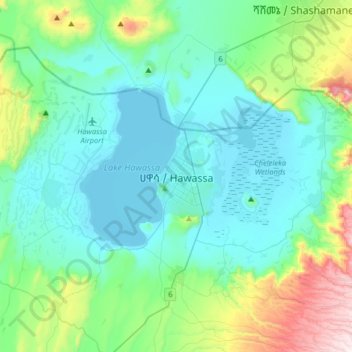
Nome: Mappa topografica Hawassa, altitudine, rilievo.
Luogo: Hawassa, Sidama, 1923, Ethiopia (6.88810 38.31861 7.20810 38.63861)
Altitudine media: 1’862 m
Altitudine minima: 1’682 m
Altitudine massima: 2’632 m
Fai una donazione
Equipaggiati per la tua prossima avventura:
In qualità di Affiliato Amazon, questo sito riceve una commissione sugli acquisti idonei, senza costi aggiuntivi per l’utente.
Altre mappe topografiche
Clicca su una mappa per visualizzarne la topografia, l'altitudine e il rilievo.
Lake Hawassa
Lake Hawassa or Awasa, is an endorheic basin in Sidama Region of Ethiopia, located in the Main Ethiopian Rift south of Addis Ababa, the capital city of the country. According to the Statistical Abstract of Ethiopia for 1967/68, the lake is 16 km long and 9 km wide, with a surface area of 129 square kilometers.…
Altitudine media: 1’705 m
Fai una donazione
Equipaggiati per la tua prossima avventura:
In qualità di Affiliato Amazon, questo sito riceve una commissione sugli acquisti idonei, senza costi aggiuntivi per l’utente.