
Mappa topografica Rio Rancho
Mappa interattiva
Clicca sulla mappa per visualizzare l'altitudine.
A proposito di questa mappa
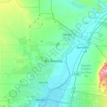
Nome: Mappa topografica Rio Rancho, altitudine, rilievo.
Luogo: Rio Rancho, Sandoval County, New Mexico, United States (35.17992 -106.86521 35.39438 -106.56700)
Altitudine media: 1’672 m
Altitudine minima: 1’518 m
Altitudine massima: 2’487 m
Rio Rancho is in an arid climate due to its location in the rain shadow of the Sandia Mountains to the east and the Continental Divide to the west. Rio Rancho receives 8.90 inches of precipitation annually on average. The western portion of the city receives slightly more rain and snowfall due to its higher elevation than that of the more densely developed eastern portion of Rio Rancho.
Altre mappe topografiche
Clicca su una mappa per visualizzarne la topografia, l'altitudine e il rilievo.
Torreon
United States > New Mexico > Sandoval County
Torreon, Eastern Navajo Agency, Sandoval County, New Mexico, United States
Altitudine media: 1’984 m
Cabezon
United States > New Mexico > Sandoval County
Cabezon, Sandoval County, New Mexico, United States
Altitudine media: 1’888 m
Placitas Homesteads
United States > New Mexico > Sandoval County
Placitas Homesteads, Sandoval County, New Mexico, 87043, United States
Altitudine media: 1’694 m