
Fai una donazione
Equipaggiati per la tua prossima avventura:
In qualità di Affiliato Amazon, questo sito riceve una commissione sugli acquisti idonei, senza costi aggiuntivi per l’utente.
Mappa topografica Wichita
Clicca sulla mappa per visualizzare l'altitudine.
Fai una donazione
Equipaggiati per la tua prossima avventura:
In qualità di Affiliato Amazon, questo sito riceve una commissione sugli acquisti idonei, senza costi aggiuntivi per l’utente.
Wichita
Wichita features a predominantly flat and gently rolling landscape characteristic of the Great Plains region. The city sits at an elevation of approximately 1,300 feet above sea level and is crisscrossed by several small rivers, including the Arkansas River, which flows through the city, providing a slight variation in terrain. The surrounding area consists of expansive agricultural fields, grasslands, and patches of wooded areas, with the Flint Hills to the east offering a more rugged terrain marked by rolling hills and tallgrass prairies. Overall, the topography of Wichita and its vicinity reflects the broader characteristics of the Great Plains, with a mix of open spaces and gentle undulations that create a scenic backdrop for both urban and rural life.
Fai una donazione
Equipaggiati per la tua prossima avventura:
In qualità di Affiliato Amazon, questo sito riceve una commissione sugli acquisti idonei, senza costi aggiuntivi per l’utente.
A proposito di questa mappa
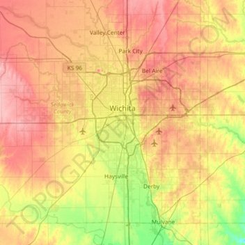
Nome: Mappa topografica Wichita, altitudine, rilievo.
Luogo: Wichita, Sedgwick County, Kansas, United States (37.48902 -97.73435 37.84020 -97.15300)
Altitudine media: 408 m
Altitudine minima: 355 m
Altitudine massima: 459 m
Fai una donazione
Equipaggiati per la tua prossima avventura:
In qualità di Affiliato Amazon, questo sito riceve una commissione sugli acquisti idonei, senza costi aggiuntivi per l’utente.
Altre mappe topografiche
Clicca su una mappa per visualizzarne la topografia, l'altitudine e il rilievo.
Fai una donazione
Equipaggiati per la tua prossima avventura:
In qualità di Affiliato Amazon, questo sito riceve una commissione sugli acquisti idonei, senza costi aggiuntivi per l’utente.