Mappa topografica Kolkata
Clicca sulla mappa per visualizzare l'altitudine.
Kolkata
Spread roughly north–south along the east bank of the Hooghly River, Kolkata sits within the lower Ganges Delta of eastern India approximately 75 km (47 mi) west of the international border with Bangladesh; the city's elevation is 1.5–9 m (5–30 ft). Much of the city was originally a wetland that was reclaimed over the decades to accommodate a burgeoning population. The remaining undeveloped areas, known as the East Kolkata Wetlands, were designated a "wetland of international importance" by the Ramsar Convention (1975). As with most of the Indo-Gangetic Plain, the soil and water are predominantly alluvial in origin. Kolkata is located over the "Bengal basin", a pericratonic tertiary basin. Bengal basin comprises three structural units: shelf or platform in the west; central hinge or shelf/slope break; and deep basinal part in the east and southeast. Kolkata is located atop the western part of the hinge zone which is about 25 km (16 mi) wide at a depth of about 45,000 m (148,000 ft) below the surface. The shelf and hinge zones have many faults, among them some are active. Total thickness of sediment below Kolkata is nearly 7,500 m (24,600 ft) above the crystalline basement; of these the top 350–450 m (1,150–1,480 ft) is Quaternary, followed by 4,500–5,500 m (14,760–18,040 ft) of Tertiary sediments, 500–700 m (1,640–2,300 ft) trap wash of Cretaceous trap and 600–800 m (1,970–2,620 ft) Permian-Carboniferous Gondwana rocks. The quaternary sediments consist of clay, silt and several grades of sand and gravel. These sediments are sandwiched between two clay beds: the lower one at a depth of 250–650 m (820–2,130 ft); the upper one 10–40 m (30–130 ft) in thickness. According to the Bureau of Indian Standards, on a scale ranging from I to V in order of increasing susceptibility to earthquakes, the city lies inside seismic zone III.
A proposito di questa mappa
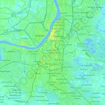
Nome: Mappa topografica Kolkata, altitudine, rilievo.
Luogo: Kolkata, West Bengal, India (22.45032 88.24062 22.63254 88.45895)
Altitudine media: 5 m
Altitudine minima: -3 m
Altitudine massima: 23 m
Altre mappe topografiche
Clicca su una mappa per visualizzarne la topografia, l'altitudine e il rilievo.