
Fai una donazione
Equipaggiati per la tua prossima avventura:
In qualità di Affiliato Amazon, questo sito riceve una commissione sugli acquisti idonei, senza costi aggiuntivi per l’utente.
Mappa topografica Indiana County
Clicca sulla mappa per visualizzare l'altitudine.
Fai una donazione
Equipaggiati per la tua prossima avventura:
In qualità di Affiliato Amazon, questo sito riceve una commissione sugli acquisti idonei, senza costi aggiuntivi per l’utente.
A proposito di questa mappa
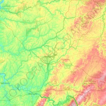
Nome: Mappa topografica Indiana County, altitudine, rilievo.
Luogo: Indiana County, Pennsylvania, United States (40.36868 -79.45964 40.91135 -78.79922)
Altitudine media: 439 m
Altitudine minima: 239 m
Altitudine massima: 817 m
Fai una donazione
Equipaggiati per la tua prossima avventura:
In qualità di Affiliato Amazon, questo sito riceve una commissione sugli acquisti idonei, senza costi aggiuntivi per l’utente.
Altre mappe topografiche
Clicca su una mappa per visualizzarne la topografia, l'altitudine e il rilievo.
East Texas
United States > Pennsylvania > Lehigh County > Lower Macungie Township
Altitudine media: 126 m
Breezewood
United States > Pennsylvania > Bedford County > East Providence Township
Altitudine media: 413 m
Fai una donazione
Equipaggiati per la tua prossima avventura:
In qualità di Affiliato Amazon, questo sito riceve una commissione sugli acquisti idonei, senza costi aggiuntivi per l’utente.
Lords Valley
United States > Pennsylvania > Pike County > Blooming Grove Township
Altitudine media: 412 m
Fai una donazione
Equipaggiati per la tua prossima avventura:
In qualità di Affiliato Amazon, questo sito riceve una commissione sugli acquisti idonei, senza costi aggiuntivi per l’utente.
Long Pond
United States > Pennsylvania > Monroe County > Tunkhannock Township
Long Pond is named after the unique wetland topography formed by the Tunkhannock Creek. Within the Long Pond community, public access lands are owned and protected by The Bethlehem Authority, Nature Conservancy, Wildlands Conservancy County of Monroe Open Space Program, , PA Game Commission and PA Department…
Altitudine media: 571 m
Plymouth Meeting
United States > Pennsylvania > Montgomery County > Whitemarsh Township
Altitudine media: 54 m
Fai una donazione
Equipaggiati per la tua prossima avventura:
In qualità di Affiliato Amazon, questo sito riceve una commissione sugli acquisti idonei, senza costi aggiuntivi per l’utente.
Blue Mountain
United States > Pennsylvania > Dauphin County > Middle Paxton Township
The ridge of Blue Mountain runs for 150 miles (240 km) through Pennsylvania, reaching an elevation of 2,270 feet (690 m) above sea level just north of the Pennsylvania Turnpike, near the borough of Newburg. Most of the ridgecrest, however, only reaches between 1,400 and 1,700 feet (430 and 520 m) in elevation.…
Altitudine media: 199 m
Flight 93 National Memorial
United States > Pennsylvania > Somerset County > Stonycreek Township
Altitudine media: 729 m
Fai una donazione
Equipaggiati per la tua prossima avventura:
In qualità di Affiliato Amazon, questo sito riceve una commissione sugli acquisti idonei, senza costi aggiuntivi per l’utente.
Mount Nebo Park
United States > Pennsylvania > Monroe County > East Stroudsburg > Twin Falls
Altitudine media: 185 m
Fai una donazione
Equipaggiati per la tua prossima avventura:
In qualità di Affiliato Amazon, questo sito riceve una commissione sugli acquisti idonei, senza costi aggiuntivi per l’utente.
Cowden
United States > Pennsylvania > Washington County > Cecil Township > Cecil
Altitudine media: 346 m
Fai una donazione
Equipaggiati per la tua prossima avventura:
In qualità di Affiliato Amazon, questo sito riceve una commissione sugli acquisti idonei, senza costi aggiuntivi per l’utente.
Fai una donazione
Equipaggiati per la tua prossima avventura:
In qualità di Affiliato Amazon, questo sito riceve una commissione sugli acquisti idonei, senza costi aggiuntivi per l’utente.
Fai una donazione
Equipaggiati per la tua prossima avventura:
In qualità di Affiliato Amazon, questo sito riceve una commissione sugli acquisti idonei, senza costi aggiuntivi per l’utente.
New Enterprise
United States > Pennsylvania > Bedford County > South Woodbury Township
Altitudine media: 397 m
Blue Knob
United States > Pennsylvania > Bedford County > Pavia Township
Blue Knob (elevation 3,146 feet (959 m)) is a summit in the eastern United States with a broad dome that is the northernmost 3,000-footer in the Allegheny Mountains. It is the highest point in Bedford County, Pennsylvania.
Altitudine media: 792 m
Saint Benedict
United States > Pennsylvania > Cambria County > West Carroll Township
Altitudine media: 582 m
Fai una donazione
Equipaggiati per la tua prossima avventura:
In qualità di Affiliato Amazon, questo sito riceve una commissione sugli acquisti idonei, senza costi aggiuntivi per l’utente.
Fort Hunter
United States > Pennsylvania > Dauphin County > Middle Paxton Township
Altitudine media: 149 m
Green Village
United States > Pennsylvania > Franklin County > Greene Township
Altitudine media: 207 m
Fai una donazione
Equipaggiati per la tua prossima avventura:
In qualità di Affiliato Amazon, questo sito riceve una commissione sugli acquisti idonei, senza costi aggiuntivi per l’utente.
Normalville
United States > Pennsylvania > Fayette County > Springfield Township
Altitudine media: 486 m
Arnold City
United States > Pennsylvania > Fayette County > Washington Township
Altitudine media: 303 m
Fai una donazione
Equipaggiati per la tua prossima avventura:
In qualità di Affiliato Amazon, questo sito riceve una commissione sugli acquisti idonei, senza costi aggiuntivi per l’utente.
Three Tuns
United States > Pennsylvania > Montgomery County > Upper Dublin Township > Maple Glen
Altitudine media: 101 m
Hidden Valley
United States > Pennsylvania > Montgomery County > Upper Merion Township
Altitudine media: 47 m
Fai una donazione
Equipaggiati per la tua prossima avventura:
In qualità di Affiliato Amazon, questo sito riceve una commissione sugli acquisti idonei, senza costi aggiuntivi per l’utente.
West Pittsburg
United States > Pennsylvania > Lawrence County > Taylor Township
Altitudine media: 279 m
Fai una donazione
Equipaggiati per la tua prossima avventura:
In qualità di Affiliato Amazon, questo sito riceve una commissione sugli acquisti idonei, senza costi aggiuntivi per l’utente.
Robinson
United States > Pennsylvania > Indiana County > West Wheatfield Township
Altitudine media: 397 m
Hazelton Mills
United States > Pennsylvania > McKean County > Bradford Township
Altitudine media: 598 m
Fogelsville
United States > Pennsylvania > Lehigh County > Upper Macungie Township
Altitudine media: 155 m
Fai una donazione
Equipaggiati per la tua prossima avventura:
In qualità di Affiliato Amazon, questo sito riceve una commissione sugli acquisti idonei, senza costi aggiuntivi per l’utente.
Mount Bethel
United States > Pennsylvania > Northampton County > Upper Mount Bethel Township
Altitudine media: 156 m
Fai una donazione
Equipaggiati per la tua prossima avventura:
In qualità di Affiliato Amazon, questo sito riceve una commissione sugli acquisti idonei, senza costi aggiuntivi per l’utente.
Reservoir Heights
United States > Pennsylvania > Dauphin County > Upper Paxton Township
Altitudine media: 189 m
Skytop
United States > Pennsylvania > Monroe County > Barrett Township
Skytop is an unincorporated community in Barrett Township, Monroe County, Pennsylvania, United States. Located north of Mountainhome, it is accessible by local roads off Route 390. Its elevation is 1,562 feet (476 m), and it is located at 41°13′40″N 75°14′18″W / 41.22778°N 75.23833°W /…
Altitudine media: 469 m
Fai una donazione
Equipaggiati per la tua prossima avventura:
In qualità di Affiliato Amazon, questo sito riceve una commissione sugli acquisti idonei, senza costi aggiuntivi per l’utente.
Ricketts Glen State Park
United States > Pennsylvania > Luzerne County > Fairmount Township
The state's original plans for the new park included building an inn, an 18-hole golf course and country club, and a winter sports complex for skiing, ice boating, and tobogganing, as well as a beach with bathing facilities, cabins, and a tent camping area. Only the last three were actually built, all south of…
Altitudine media: 588 m
Mount Cobb
United States > Pennsylvania > Lackawanna County > Jefferson Township
Altitudine media: 529 m
Pastorius Park
United States > Pennsylvania > Philadelphia County > Philadelphia
Altitudine media: 108 m
Fai una donazione
Equipaggiati per la tua prossima avventura:
In qualità di Affiliato Amazon, questo sito riceve una commissione sugli acquisti idonei, senza costi aggiuntivi per l’utente.
Danielsville
United States > Pennsylvania > Northampton County > Lehigh Township
Altitudine media: 254 m
Blue Mountain
United States > Pennsylvania > Monroe County > Eldred Township
The ridge of Blue Mountain runs for 150 miles (240 km) through Pennsylvania, reaching an elevation of 2,270 feet (690 m) above sea level just north of the Pennsylvania Turnpike, near the borough of Newburg. Most of the ridgecrest, however, only reaches between 1,400 and 1,700 feet (430 and 520 m) in elevation.…
Altitudine media: 242 m
Fai una donazione
Equipaggiati per la tua prossima avventura:
In qualità di Affiliato Amazon, questo sito riceve una commissione sugli acquisti idonei, senza costi aggiuntivi per l’utente.
Park Place
United States > Pennsylvania > Schuylkill County > Mahanoy Township
Altitudine media: 515 m
Portlamd Waterfront Park
United States > Pennsylvania > Northampton County > Portland
Altitudine media: 118 m
Fai una donazione
Equipaggiati per la tua prossima avventura:
In qualità di Affiliato Amazon, questo sito riceve una commissione sugli acquisti idonei, senza costi aggiuntivi per l’utente.
Stevens Point
United States > Pennsylvania > Susquehanna County > Harmony Township
Altitudine media: 434 m
Pendle Hill
United States > Pennsylvania > Delaware County > Nether Providence Township
Altitudine media: 61 m
Fai una donazione
Equipaggiati per la tua prossima avventura:
In qualità di Affiliato Amazon, questo sito riceve una commissione sugli acquisti idonei, senza costi aggiuntivi per l’utente.
Longwood Gardens
United States > Pennsylvania > Chester County > East Marlborough Township
Altitudine media: 125 m
Nottingham County Park
United States > Pennsylvania > Chester County > West Nottingham Township
Altitudine media: 137 m
Marble Hall
United States > Pennsylvania > Montgomery County > Whitemarsh Township
Altitudine media: 64 m
Fai una donazione
Equipaggiati per la tua prossima avventura:
In qualità di Affiliato Amazon, questo sito riceve una commissione sugli acquisti idonei, senza costi aggiuntivi per l’utente.
Circleville
United States > Pennsylvania > Westmoreland County > North Huntingdon Township
Altitudine media: 333 m
Fai una donazione
Equipaggiati per la tua prossima avventura:
In qualità di Affiliato Amazon, questo sito riceve una commissione sugli acquisti idonei, senza costi aggiuntivi per l’utente.
Chadds Ford Township
United States > Pennsylvania > Delaware County > Chadds Ford Township
Altitudine media: 101 m
Strawberry Mansion
United States > Pennsylvania > Philadelphia County > Philadelphia
Altitudine media: 31 m
Reinholds
United States > Pennsylvania > Lancaster County > West Cocalico Township
Altitudine media: 159 m
Fai una donazione
Equipaggiati per la tua prossima avventura:
In qualità di Affiliato Amazon, questo sito riceve una commissione sugli acquisti idonei, senza costi aggiuntivi per l’utente.
Langhorne Gardens
United States > Pennsylvania > Bucks County > Middletown Township
Altitudine media: 45 m
Fai una donazione
Equipaggiati per la tua prossima avventura:
In qualità di Affiliato Amazon, questo sito riceve una commissione sugli acquisti idonei, senza costi aggiuntivi per l’utente.
Hanover Junction
United States > Pennsylvania > York County > North Codorus Township
Altitudine media: 187 m
Champion
United States > Pennsylvania > Allegheny County > North Fayette Township
Altitudine media: 360 m
Fai una donazione
Equipaggiati per la tua prossima avventura:
In qualità di Affiliato Amazon, questo sito riceve una commissione sugli acquisti idonei, senza costi aggiuntivi per l’utente.