
Mappa topografica De Smet
Mappa interattiva
Clicca sulla mappa per visualizzare l'altitudine.
De Smet
U.S. Route 95 passes nearby and the community is located about a mile (1.6 km) south of Tensed, which was originally also to be titled Desmet before the name was ordered to be reversed and was subsequently misspelled by the post office. Latah Creek flows between the two communities. De Smet has a post office with a ZIP code of 83824. As of the 2010 census, its population was 145, and its elevation is approximately 2,600 feet (790 m) above sea level.
A proposito di questa mappa
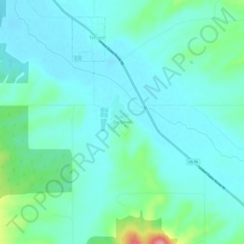
Nome: Mappa topografica De Smet, altitudine, rilievo.
Luogo: De Smet, Benewah County, Idaho, 83824, United States (47.12601 -116.93572 47.16601 -116.89572)
Altitudine media: 794 m
Altitudine minima: 771 m
Altitudine massima: 894 m
Altre mappe topografiche
Clicca su una mappa per visualizzarne la topografia, l'altitudine e il rilievo.
Tensed
United States > Idaho > Benewah County
Tensed is located at 47°9′37″N 116°55′27″W / 47.16028°N 116.92417°W / 47.16028; -116.92417 (47.160284, -116.924304), at an elevation of 2,562 feet (781 m) above sea level.
Altitudine media: 785 m