
Mappa topografica Gulf Shores
Mappa interattiva
Clicca sulla mappa per visualizzare l'altitudine.
A proposito di questa mappa
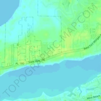
Nome: Mappa topografica Gulf Shores, altitudine, rilievo.
Altitudine media: 5 m
Altitudine minima: -3 m
Altitudine massima: 13 m
Jack Edwards National Airport is located in Gulf Shores and offers services from Gulf Air Center, Salt Air Aviation Center and Platium Air Center. The airport is located in town, two miles from the beach. Their FBO Gulf Air Center will provide a rental vehicle while they take care of fueling and storing aircraft. There is 48-hour and long term parking available. The longest paved runway extends 6,962 feet. The facility is at an elevation of 17 feet. They offer outside tiedown as well as hangar space for aircraft. They can provide space by the night, week or month.
Altre mappe topografiche
Clicca su una mappa per visualizzarne la topografia, l'altitudine e il rilievo.
Gulf Shores
United States of America > Alabama > Gulf Shores
Gulf Shores, Baldwin County, Alabama, United States of America
Altitudine media: 6 m