Geolocalizza

Mappa topografica Grattan

Clicca sulla mappa per visualizzare l'altitudine.

A proposito di questa mappa

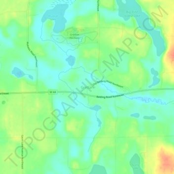
Nome: Mappa topografica Grattan, altitudine, rilievo.

Luogo: Grattan, Grattan Township, Kent County, Michigan, United States (43.06420 -85.40113 43.10420 -85.36113)

Altitudine media: 261 m

Altitudine minima: 244 m

Altitudine massima: 291 m

Altre mappe topografiche

Clicca su una mappa per visualizzarne la topografia, l'altitudine e il rilievo.

Grand Rapids

United States > Michigan > Kent County

Grand Rapids is situated in a region characterized by relatively flat terrain that gently undulates, influenced by the glacial activity that shaped much of the Midwest. The city itself sits at an elevation of approximately 640 feet (195 meters) above sea level, with the surrounding landscape showcasing low…

Altitudine media: 216 m

Rockford

United States > Michigan > Kent County

Altitudine media: 239 m

Wyoming

United States > Michigan > Kent County

Altitudine media: 204 m

Kentwood

United States > Michigan > Kent County

Altitudine media: 216 m

Walker

United States > Michigan > Kent County

Altitudine media: 209 m

Sparta

United States > Michigan > Kent County

Altitudine media: 235 m

Harvard Lake

United States > Michigan > Kent County > Harvard

Altitudine media: 267 m

Sand Lake

United States > Michigan > Kent County

Altitudine media: 277 m

Grandville

United States > Michigan > Kent County

Altitudine media: 193 m

Cedar Springs

United States > Michigan > Kent County

Altitudine media: 262 m

Lowell

United States > Michigan > Kent County

Altitudine media: 206 m

Kettle Lake

United States > Michigan > Kent County

Altitudine media: 239 m

Grand Rapids

United States > Michigan > Kent County

Grand Rapids developed on the banks of the Grand River, where there was once a set of rapids, at an altitude of 610 feet (186 m) above sea level. Ships could navigate on the river up to this fall line, stopping because of the rapids. The river valley is flat and narrow, surrounded by steep hills and bluffs.…

Altitudine media: 216 m

Walker

United States > Michigan > Kent County

Altitudine media: 209 m

Kent City

United States > Michigan > Kent County

Altitudine media: 251 m

Rockford

United States > Michigan > Kent County

Altitudine media: 239 m

Algoma Township

United States > Michigan > Kent County

Altitudine media: 242 m

Kentwood

United States > Michigan > Kent County

Altitudine media: 216 m

Grand Rapids

United States > Michigan > Kent County

Grand Rapids developed on the banks of the Grand River, where there was once a set of rapids, at an altitude of 610 feet (186 m) above sea level. Ships could navigate on the river up to this fall line, stopping because of the rapids. The river valley is flat and narrow, surrounded by steep hills and bluffs.…

Altitudine media: 216 m

Lowell

United States > Michigan > Kent County

Altitudine media: 206 m

Sparta Township

United States > Michigan > Kent County

Altitudine media: 246 m

Byron Township

United States > Michigan > Kent County

Altitudine media: 221 m

Creekside Park

United States > Michigan > Kent County > Lowell

Altitudine media: 201 m

Sand Lake

United States > Michigan > Kent County

Altitudine media: 277 m

Equipaggiati per la tua prossima avventura:

🛠️Attrezzi Multiuso - Utensili compatti per riparazioni outdoor
📡Antenna GPS Estesa - Antenna per migliorare segnale GPS
🎿Ciaspole da Neve - Racchette da neve per camminare agevolmente su manti freschi
Moschettoni a Ghiera - Connettori certificati per manovre di corda e assicurazione
🚴Lucchetto per Bici - Lucchetto resistente per sicurezza della bici

In qualità di Affiliato Amazon, questo sito riceve una commissione sugli acquisti idonei, senza costi aggiuntivi per l’utente.