
Fai una donazione
Equipaggiati per la tua prossima avventura:
In qualità di Affiliato Amazon, questo sito riceve una commissione sugli acquisti idonei, senza costi aggiuntivi per l’utente.
Mappa topografica Ruthin
Clicca sulla mappa per visualizzare l'altitudine.
Fai una donazione
Equipaggiati per la tua prossima avventura:
In qualità di Affiliato Amazon, questo sito riceve una commissione sugli acquisti idonei, senza costi aggiuntivi per l’utente.
Ruthin
The Myddleton Arms is also known as the Seven Eyes. It is said to have been built in the 14th century. The Dutch style design, long, steeped roof is attributed to Sir Richard Clough, an Elizabethan merchant. It has four tiers of dormer windows, each at a different elevation, known locally as the seven eyes of Ruthin. The property was acquired in 1595 by Sir Hugh Myddleton, who provided London with it first fresh water supply. The view of The Myddleton on the square is in fact of the rear of the building. The front looks out over the Clwydian Hills.
Fai una donazione
Equipaggiati per la tua prossima avventura:
In qualità di Affiliato Amazon, questo sito riceve una commissione sugli acquisti idonei, senza costi aggiuntivi per l’utente.
A proposito di questa mappa
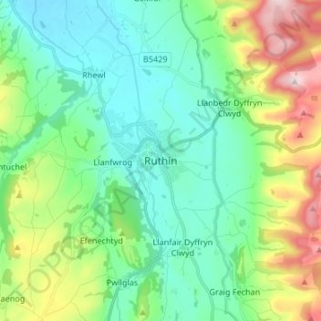
Nome: Mappa topografica Ruthin, altitudine, rilievo.
Luogo: Ruthin, Denbighshire, Wales, LL15 1BU, United Kingdom (53.07155 -3.34524 53.15155 -3.26524)
Altitudine media: 162 m
Altitudine minima: 35 m
Altitudine massima: 505 m
Fai una donazione
Equipaggiati per la tua prossima avventura:
In qualità di Affiliato Amazon, questo sito riceve una commissione sugli acquisti idonei, senza costi aggiuntivi per l’utente.
Altre mappe topografiche
Clicca su una mappa per visualizzarne la topografia, l'altitudine e il rilievo.
Fai una donazione
Equipaggiati per la tua prossima avventura:
In qualità di Affiliato Amazon, questo sito riceve una commissione sugli acquisti idonei, senza costi aggiuntivi per l’utente.
Fai una donazione
Equipaggiati per la tua prossima avventura:
In qualità di Affiliato Amazon, questo sito riceve una commissione sugli acquisti idonei, senza costi aggiuntivi per l’utente.
Clwydian Range and Dee Valley National Landscape
United Kingdom > Wales > Denbighshire
Separated by the Vale of Alyn, a second sister range, sometimes regarded (at least partly) as part of the Clwydian Range and included in the AONB since 2011, the Llantysilio and Maesyrchen Mountains, or South Clwyd Mountains extend further south to Acrefair and Gwyddelwern. Alongside the (core–northern)…
Altitudine media: 166 m
Fai una donazione
Equipaggiati per la tua prossima avventura:
In qualità di Affiliato Amazon, questo sito riceve una commissione sugli acquisti idonei, senza costi aggiuntivi per l’utente.
Coed Rhedyn-coch
United Kingdom > Wales > Denbighshire > St Asaph > Marian Cwm
Altitudine media: 196 m
Fai una donazione
Equipaggiati per la tua prossima avventura:
In qualità di Affiliato Amazon, questo sito riceve una commissione sugli acquisti idonei, senza costi aggiuntivi per l’utente.