
Mappa topografica Oakridge
Mappa interattiva
Clicca sulla mappa per visualizzare l'altitudine.
A proposito di questa mappa
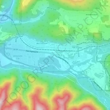
Nome: Mappa topografica Oakridge, altitudine, rilievo.
Luogo: Oakridge, Lane County, Oregon, United States (43.73131 -122.49623 43.75831 -122.43861)
Altitudine media: 465 m
Altitudine minima: 323 m
Altitudine massima: 848 m
The city was originally a community called "Hazeldell", and its post office was established on July 26, 1888. When a station on the Southern Pacific Railroad opened in May 1912, it was named "Oak Ridge" by a railroad executive for the surrounding topography, and on July 19 of that year the name was changed to be spelled as a single word.
Altre mappe topografiche
Clicca su una mappa per visualizzarne la topografia, l'altitudine e il rilievo.
Cottage Grove
United States > Oregon > Lane County
Cottage Grove, Lane County, Oregon, 97424, United States
Altitudine media: 230 m
Springfield
United States > Oregon > Lane County
Springfield, Lane County, Oregon, United States
Altitudine media: 177 m
Eugene
United States > Oregon > Lane County
Eugene, Lane County, Oregon, United States
Altitudine media: 163 m