
Mappa topografica Marysville
Mappa interattiva
Clicca sulla mappa per visualizzare l'altitudine.
A proposito di questa mappa
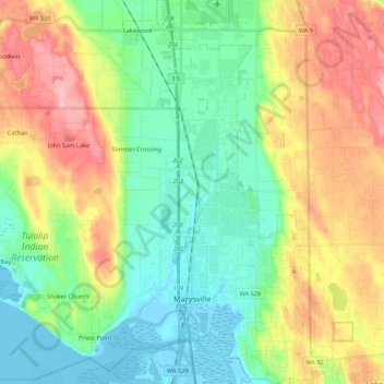
Nome: Mappa topografica Marysville, altitudine, rilievo.
Luogo: Marysville, Snohomish County, Washington, United States (48.01984 -122.28651 48.16329 -122.10961)
Altitudine media: 72 m
Altitudine minima: -3 m
Altitudine massima: 201 m
The city's topography varies from the low-lying downtown, located along the banks of Ebey Slough 5 feet (1.5 m) above sea level, rising to 160 feet (49 m) near Smokey Point and over 465 feet (142 m) in the eastern highlands. Marysville sits in the watershed of two major creeks, Quilceda Creek and Allen Creek, and approximately 70 minor streams that flow into Ebey Slough and Snohomish River. During the early 20th century, repeated controlled flooding and other engineering works in the Snohomish River delta contributed to the replenishment of the area's fertile silty soil for use in farming.
Altre mappe topografiche
Clicca su una mappa per visualizzarne la topografia, l'altitudine e il rilievo.
Lynnwood
United States > Washington > Snohomish County
Lynnwood, Snohomish County, Washington, 98037, United States
Altitudine media: 121 m
Everett
United States > Washington > Snohomish County
Everett, Snohomish County, Washington, United States
Altitudine media: 66 m
Granite Falls
United States > Washington > Snohomish County
Granite Falls, Snohomish County, Washington, United States
Altitudine media: 120 m
Mill Creek
United States > Washington > Snohomish County
Mill Creek, Snohomish County, Washington, United States
Altitudine media: 130 m
Mukilteo
United States > Washington > Snohomish County
Mukilteo, Snohomish County, Washington, 98275, United States
Altitudine media: 89 m
Everett
United States > Washington > Snohomish County > Everett
Everett, Snohomish County, Washington, 98120, United States
Altitudine media: 67 m