
Mappa topografica Ketchikan
Mappa interattiva
Clicca sulla mappa per visualizzare l'altitudine.
A proposito di questa mappa
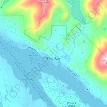
Nome: Mappa topografica Ketchikan, altitudine, rilievo.
Luogo: Ketchikan, Ketchikan Gateway, Alaska, 99901, United States (55.32653 -131.70734 55.36437 -131.61494)
Altitudine media: 149 m
Altitudine minima: -2 m
Altitudine massima: 848 m
Due to its steep and forested terrain, Ketchikan is long and narrow with much of the built-up area being located along, or no more than a few city blocks from, the waterfront. Elevations of inhabited areas range from just above sea level to about 300 feet (91 m). Deer Mountain, a 3,001-foot (915 m) peak, rises immediately east of the city's downtown area.