
Fai una donazione
Equipaggiati per la tua prossima avventura:
In qualità di Affiliato Amazon, questo sito riceve una commissione sugli acquisti idonei, senza costi aggiuntivi per l’utente.
Mappa topografica Isla Cozumel
Clicca sulla mappa per visualizzare l'altitudine.
Fai una donazione
Equipaggiati per la tua prossima avventura:
In qualità di Affiliato Amazon, questo sito riceve una commissione sugli acquisti idonei, senza costi aggiuntivi per l’utente.
Isla Cozumel
Cozumel has 5 main piers. Punta Langosta, the International Pier (SSA), and Puerta Maya are all piers for cruise ships. A ferry pier in San Miguel is used for passenger ferries to and from Playa del Carmen, as well as for cruise ship tenders. A fifth pier south of downtown is used only for vehicle ferries. Large parts of the island are covered with mangrove forest which has many endemic animal species. Cozumel is a flat island based on limestone, resulting in a karst topography. The highest natural point on the island is less than 15 m (49 ft) above sea level. The cenotes are water-filled sinkholes formed by water percolating through the soft limestone soil for thousands of years. Eighteen deep cenotes and more than 250 shallow bodies exist on the island. Many are under dense vegetation. Jade Cavern Cozumel (Cenote Chempita) near El Cedral is often visited by tourists.
Fai una donazione
Equipaggiati per la tua prossima avventura:
In qualità di Affiliato Amazon, questo sito riceve una commissione sugli acquisti idonei, senza costi aggiuntivi per l’utente.
A proposito di questa mappa
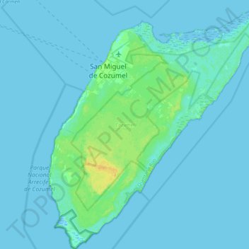
Nome: Mappa topografica Isla Cozumel, altitudine, rilievo.
Luogo: Isla Cozumel, Cozumel, Quintana Roo, Mexico (20.27200 -87.02520 20.59200 -86.72328)
Altitudine media: 2 m
Altitudine minima: -3 m
Altitudine massima: 18 m
Fai una donazione
Equipaggiati per la tua prossima avventura:
In qualità di Affiliato Amazon, questo sito riceve una commissione sugli acquisti idonei, senza costi aggiuntivi per l’utente.