
Mappa topografica Kingsville
Mappa interattiva
Clicca sulla mappa per visualizzare l'altitudine.
A proposito di questa mappa
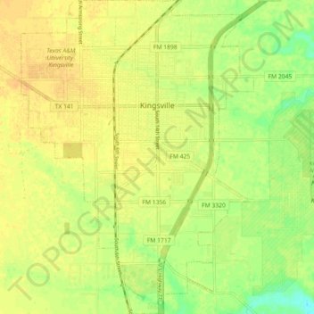
Nome: Mappa topografica Kingsville, altitudine, rilievo.
Luogo: Kingsville, Kleberg County, Texas, 78363, United States (27.46295 -97.89506 27.54248 -97.82856)
Altitudine media: 19 m
Altitudine minima: 2 m
Altitudine massima: 27 m
Kingsville is located in the historic Wild Horse Desert, an area of South Texas and northern Mexico where enormous herds of wild mustangs roamed. Due to water pumping and other environmental factors, the abundance of spring-fed creeks has decreased. Wildlife surrounding Kingsville include deer, wild turkey, and javelinas. Additionally, Kingsville is a winter home to a large number of waterfowl species, including geese, ducks, and pelicans. The city is surrounded by farmland producing various crops including cotton and sorghum. The terrain around Kingsville is generally flat, with an elevation of 59 feet above sea level at city center.
Altre mappe topografiche
Clicca su una mappa per visualizzarne la topografia, l'altitudine e il rilievo.
Padre Island National Seashore
United States > Texas > Kleberg County
Padre Island National Seashore, 20301, Park Road 22, Kleberg County, Texas, 78418, United States
Altitudine media: 5 m