
Mappa topografica County Limerick
Mappa interattiva
Clicca sulla mappa per visualizzare l'altitudine.
A proposito di questa mappa
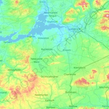
Nome: Mappa topografica County Limerick, altitudine, rilievo.
Luogo: County Limerick, Munster, Ireland (52.28020 -9.36543 52.69629 -8.15637)
Altitudine media: 107 m
Altitudine minima: -2 m
Altitudine massima: 688 m
One possible meaning for the county's name in Irish Luimneach is "the flat area"; this description is accurate as the land consists mostly of a fertile limestone plain. Moreover, the county is ringed by mountains: the Slieve Felims to the northeast, the Galtees to the southeast, the Ballyhoura Mountains to the south, and the Mullaghareirk Mountains to the southwest and west. The highest point in the county is located in its southeast corner at Galtymore (919 m), which separates Limerick from County Tipperary. Limerick shares the 3rd-highest county peak in Ireland with Tipperary. The county is not simply a plain, its topography consists of hills and ridges. The eastern part of the county is part of the Golden Vale, which is well known for dairy produce and consists of rolling low hills. This gives way to very flat land around the centre of the county, with the exception being Knockfierna at 288 m high. Towards the west, the Mullaghareirk Mountains (Mullach an Radhairc in Irish, roughly meaning "mountains of the view") push across the county offering extensive views east over the county and west into County Kerry.
Altre mappe topografiche
Clicca su una mappa per visualizzarne la topografia, l'altitudine e il rilievo.
Galway City
Galway, Galway City, County Galway, Connacht, H91 YD86, Ireland
Altitudine media: 26 m
Comeragh
Comeragh, The Municipal District of Comeragh, County Waterford, Munster, Ireland
Altitudine media: 215 m
Ballincollig
Ireland > County Cork > Cork
Ballincollig, Cork, County Cork, Munster, P31 TW88, Ireland
Altitudine media: 62 m
Lanesborough
Lanesborough, Ballymahon Municipal District, County Longford, Leinster, Ireland
Altitudine media: 41 m
Adare
Ireland > County Limerick > The Municipal District of Adare — Rathkeale
Adare, The Municipal District of Adare — Rathkeale, County Limerick, Munster, Ireland
Altitudine media: 12 m
Cordarragh
Cordarragh, Headford ED, Tuam Municipal District, County Galway, Connacht, Ireland
Altitudine media: 20 m
Summerhill
Summerhill, Summerhill ED, The Municipal District of Trim, County Meath, Leinster, Ireland
Altitudine media: 86 m
Curraghboy
Curraghboy, Rockhill Electoral Division, Athlone Municipal District, County Roscommon, Connacht, N37 EK20, Ireland
Altitudine media: 69 m
Kilcurriv Eighter
Kilcurriv Eighter, Killower ED, Tuam Municipal District, County Galway, Connacht, Ireland
Altitudine media: 48 m
Cahir
Cahir, The Municipal District of Cahir — Cashel, County Tipperary, Munster, Ireland
Altitudine media: 58 m
Mount Lucas
Mount Lucas, Esker ED, The Municipal District of Edenderry, County Offaly, Leinster, R35 XW10, Ireland
Altitudine media: 76 m
Lettermore
Lettermore, Lettermore ED, Conamara Municipal District, County Galway, Connacht, Ireland
Altitudine media: 8 m
Broadlough
Broadlough, Ardee Rural ED, The Municipal District of Ardee, County Louth, Leinster, Ireland
Altitudine media: 34 m
Callanagh Lower
Callanagh Lower, Drumlumman ED, Ballyjamesduff Municipal District, County Cavan, Ulster, Ireland
Altitudine media: 85 m
Gorteennakilla
Gorteennakilla, Youghalarra, The Municipal District of Nenagh, County Tipperary, Munster, Ireland
Altitudine media: 57 m
Kiltole
Kiltole, Figart ED, Lifford-Stranorlar Municipal District, County Donegal, Ireland
Altitudine media: 49 m
Lough Bane
Lough Bane, Crosskeys ED, The Municipal District of Kells, County Westmeath, County Meath, Leinster, Ireland
Altitudine media: 130 m
Durrow
Durrow, The Municipal District of Tullamore, County Offaly, Leinster, R35 X865, Ireland
Altitudine media: 66 m
Inchigeelagh
Inchigeelagh, Municipal District of Macroom, County Cork, Munster, P12 W864, Ireland
Altitudine media: 135 m
Moorock
Moorock, Ballycumber ED, The Municipal District of Tullamore, County Offaly, Leinster, Ireland
Altitudine media: 64 m
Barnadown
Barnadown, Aghaviller, The Municipal District of Callan — Thomastown, County Kilkenny, Leinster, Ireland
Altitudine media: 212 m
Shronowen
Shronowen, Shronowen ED, Listowel Municipal District, County Kerry, Munster, Ireland
Altitudine media: 27 m
Pembrokestown
Pembrokestown, Waterford City Metropolitan District, County Waterford, Munster, X91 R6CA, Ireland
Altitudine media: 57 m
Smithstown
Smithstown, Ballinlough ED, The Municipal District of Kells, County Meath, Leinster, Ireland
Altitudine media: 121 m
Cloonmore
Cloonmore, Belclare ED, Tuam Municipal District, County Galway, Connacht, Ireland
Altitudine media: 33 m
Ballyhaunis
Ballyhaunis, Claremorris-Swinford Municipal District, County Mayo, Connacht, F35 NF82, Ireland
Altitudine media: 87 m
Ballinaclogh
Ballinaclogh, Glenealy ED, The Municipal District of Wicklow, County Wicklow, Leinster, Ireland
Altitudine media: 108 m
Priorswood
Ireland > County Dublin > Dublin
Priorswood, Priorswood E Ward 1986, Dublin, County Dublin, Leinster, D17 XV48, Ireland
Altitudine media: 42 m
Pollduff
Pollduff, Loughrea Municipal District, County Galway, Connacht, Ireland
Altitudine media: 219 m
Ballyboughal
Ballyboughal, Ballyboghil DED 1986, Fingal, County Dublin, Leinster, Ireland
Altitudine media: 35 m
Upper Lough Bray
Upper Lough Bray, Powerscourt ED, The Municipal District of Bray, County Wicklow, Leinster, Ireland
Altitudine media: 496 m
Yellowmeadows
Yellowmeadows, Clondalkin-Monastery DED 1986, South Dublin, County Dublin, Leinster, Ireland
Altitudine media: 59 m
Dawros
Dawros, Banada ED, Ballymote-Tubbercurry Municipal District, County Sligo, Connacht, Ireland
Altitudine media: 52 m
Knockawaddra
Knockawaddra, Ballingurteen ED, West Cork, County Cork, Munster, Ireland
Altitudine media: 154 m
Dehomad
Dehomad, Clondagad ED, West Clare Municipal District, County Clare, Munster, Ireland
Altitudine media: 130 m
Lissycasey
Lissycasey, West Clare Municipal District, County Clare, Munster, Ireland
Altitudine media: 101 m
Aghafin
Aghafin, Aghafin ED, Boyle Municipal District, County Roscommon, Connacht, Ireland
Altitudine media: 50 m
Lissaviron
Lissaviron, Annestown ED, The Municipal District of Comeragh, County Waterford, Munster, Ireland
Altitudine media: 60 m