
Mappa topografica County Wicklow
Mappa interattiva
Clicca sulla mappa per visualizzare l'altitudine.
A proposito di questa mappa
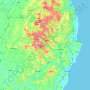
Nome: Mappa topografica County Wicklow, altitudine, rilievo.
Luogo: County Wicklow, Leinster, Ireland (52.68198 -6.79229 53.23431 -5.99758)
Altitudine media: 166 m
Altitudine minima: 0 m
Altitudine massima: 927 m
The county experiences a narrow annual temperature range. Typical daytime highs range from 17–22 °C (63–72 °F) throughout the county in July and August, with overnight lows in the 11–14 °C (52–57 °F) range, although temperatures in the mountains can be 5–10 °C (41–50 °F) lower. Mean January temperatures range from 7 °C (45 °F) on the coast to 0 °C (32 °F) at high elevations. Precipitation is fairly evenly distributed throughout the year, although the wettest months (October and November) receive roughly twice as much rain as the driest months (February, March and April). The driest area of Wicklow is the northeast corner of the county, which is protected from the prevailing south-westerly winds by the Wicklow Mountains and receives around 750 mm (30 in) of rainfall per year. The coastal region of County Dublin immediately to the north is the driest location in all of Ireland as a result of the rain shadow created by the mountains.
Altre mappe topografiche
Clicca su una mappa per visualizzarne la topografia, l'altitudine e il rilievo.
Dromore West
Dromore West, Ballymote-Tubbercurry Municipal District, County Sligo, Connacht, Ireland
Altitudine media: 51 m
Ballyseedy Wood
Ballyseedy Wood, Ballyseedy ED, Tralee Municipal District, County Kerry, Munster, Ireland
Altitudine media: 20 m
Moyglare
Moyglare, Rodanstown ED, The Municipal District of Ratoath, County Meath, Leinster, W23 RT91, Ireland
Altitudine media: 66 m
Ballybrack
Ballybrack, Moville ED, Inishowen Municipal District, County Donegal, Ireland
Altitudine media: 147 m
Conaghy
Conaghy, Killeevan ED, Ballybay-Clones Municipal District, County Monaghan, Ulster, Ireland
Altitudine media: 67 m
Johnstown
Johnstown, The Municipal District of Naas, County Kildare, Leinster, W91 Y3CP, Ireland
Altitudine media: 97 m
Gort
Gort, Loughrea Municipal District, County Galway, Connacht, H91 R5F9, Ireland
Altitudine media: 27 m
Cloonkeenkerrill
Cloonkeenkerrill, Colmanstown ED, Ballinasloe Municipal District, County Galway, Connacht, Ireland
Altitudine media: 88 m
Colmanstown
Colmanstown, Killofin ED, West Clare Municipal District, County Clare, Munster, Ireland
Altitudine media: 24 m
Morristown
Morristown, Rathmore ED, The Municipal District of Naas, County Kildare, Leinster, Ireland
Altitudine media: 113 m
Galway City
Galway, Galway City, County Galway, Connacht, H91 YD86, Ireland
Altitudine media: 26 m
Kilkenny
Kilkenny, The Municipal District of Kilkenny City, County Kilkenny, Leinster, Ireland
Altitudine media: 61 m
Ballincollig
Ireland > County Cork > Cork
Ballincollig, Cork, County Cork, Munster, P31 TW88, Ireland
Altitudine media: 62 m
Cordarragh
Cordarragh, Headford ED, Tuam Municipal District, County Galway, Connacht, Ireland
Altitudine media: 20 m
Comeragh
Comeragh, The Municipal District of Comeragh, County Waterford, Munster, Ireland
Altitudine media: 215 m
Sligo
Sligo, Sligo Municipal Borough District, County Sligo, Connacht, Ireland
Altitudine media: 21 m
Adare
Ireland > County Limerick > The Municipal District of Adare — Rathkeale
Adare, The Municipal District of Adare — Rathkeale, County Limerick, Munster, Ireland
Altitudine media: 12 m
Lanesborough
Lanesborough, Ballymahon Municipal District, County Longford, Leinster, Ireland
Altitudine media: 41 m
Curraghboy
Curraghboy, Rockhill Electoral Division, Athlone Municipal District, County Roscommon, Connacht, N37 EK20, Ireland
Altitudine media: 69 m
Summerhill
Summerhill, Summerhill ED, The Municipal District of Trim, County Meath, Leinster, Ireland
Altitudine media: 86 m
Gorteennakilla
Gorteennakilla, Youghalarra, The Municipal District of Nenagh, County Tipperary, Munster, Ireland
Altitudine media: 57 m
Kilcurriv Eighter
Kilcurriv Eighter, Killower ED, Tuam Municipal District, County Galway, Connacht, Ireland
Altitudine media: 48 m
Cahir
Cahir, The Municipal District of Cahir — Cashel, County Tipperary, Munster, Ireland
Altitudine media: 58 m
Callanagh Lower
Callanagh Lower, Drumlumman ED, Ballyjamesduff Municipal District, County Cavan, Ulster, Ireland
Altitudine media: 85 m
Ballyhaunis
Ballyhaunis, Claremorris-Swinford Municipal District, County Mayo, Connacht, F35 NF82, Ireland
Altitudine media: 87 m
Mount Lucas
Mount Lucas, Esker ED, The Municipal District of Edenderry, County Offaly, Leinster, R35 XW10, Ireland
Altitudine media: 76 m
Lough Bane
Lough Bane, Crosskeys ED, The Municipal District of Kells, County Westmeath, County Meath, Leinster, Ireland
Altitudine media: 130 m
Lettermore
Lettermore, Lettermore ED, Conamara Municipal District, County Galway, Connacht, Ireland
Altitudine media: 8 m
Upper Lough Bray
Upper Lough Bray, Powerscourt ED, The Municipal District of Bray, County Wicklow, Leinster, Ireland
Altitudine media: 496 m
Broadlough
Broadlough, Ardee Rural ED, The Municipal District of Ardee, County Louth, Leinster, Ireland
Altitudine media: 34 m
Moorock
Moorock, Ballycumber ED, The Municipal District of Tullamore, County Offaly, Leinster, Ireland
Altitudine media: 64 m
Barnadown
Barnadown, Aghaviller, The Municipal District of Callan — Thomastown, County Kilkenny, Leinster, Ireland
Altitudine media: 212 m
Shronowen
Shronowen, Shronowen ED, Listowel Municipal District, County Kerry, Munster, Ireland
Altitudine media: 27 m
Pembrokestown
Pembrokestown, Waterford City Metropolitan District, County Waterford, Munster, X91 R6CA, Ireland
Altitudine media: 57 m
Smithstown
Smithstown, Ballinlough ED, The Municipal District of Kells, County Meath, Leinster, Ireland
Altitudine media: 121 m
Ballinaclogh
Ballinaclogh, Glenealy ED, The Municipal District of Wicklow, County Wicklow, Leinster, Ireland
Altitudine media: 108 m
Pollduff
Pollduff, Loughrea Municipal District, County Galway, Connacht, Ireland
Altitudine media: 219 m
Kiltole
Kiltole, Figart ED, Lifford-Stranorlar Municipal District, County Donegal, Ireland
Altitudine media: 49 m