
Mappa topografica Schefferville
Mappa interattiva
Clicca sulla mappa per visualizzare l'altitudine.
A proposito di questa mappa
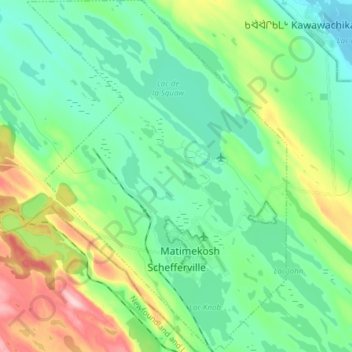
Nome: Mappa topografica Schefferville, altitudine, rilievo.
Altitudine media: 537 m
Altitudine minima: 476 m
Altitudine massima: 699 m
The cold winters are caused in part by elevation, and in part the ice cover of Hudson Bay eliminating maritime moderation in winter. Although Schefferville is nearer the Atlantic, the cold Labrador Current brings cold air also from the east. In summer, the Hudson Bay water is cold after just thawing, and the Labrador waters remains cool and prone to low-pressure systems under the Icelandic Low. As a result, even the vast landmass seldom builds up heat and remains extremely chilly for the latitude. Areas on similar or higher latitudes in western Canada are much warmer also in this time of the year as a result. The low mean annual air temperature of -5.3 °C indicates widespread occurrences of permafrost.
Altre mappe topografiche
Clicca su una mappa per visualizzarne la topografia, l'altitudine e il rilievo.
Rivière Moisie
Canada > Quebec > Caniapiscau (MRC) > Rivière-Mouchalagane
Rivière Moisie, Rivière-Mouchalagane, Caniapiscau (MRC), Côte-Nord, Quebec, Canada
Altitudine media: 507 m
Fermont
Canada > Quebec > Caniapiscau (MRC)
Fermont, Caniapiscau (MRC), Côte-Nord, Quebec, G0G 1J0, Canada
Altitudine media: 632 m