
Mappa topografica Grande Prairie
Mappa interattiva
Clicca sulla mappa per visualizzare l'altitudine.
A proposito di questa mappa
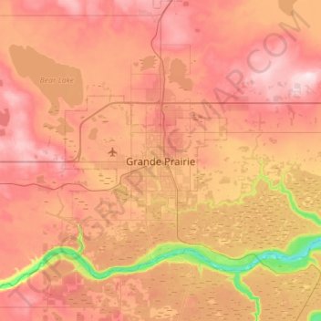
Nome: Mappa topografica Grande Prairie, altitudine, rilievo.
Altitudine media: 668 m
Altitudine minima: 498 m
Altitudine massima: 793 m
Grande Prairie is located just north of the 55th parallel north, and is 465 km (289 mi) northwest of Edmonton, lying at an elevation of 669 m (2,195 ft) above sea level. The city is surrounded by farmland to the north, east, and west. To the south lies a vast boreal forest with aspen, tamarack, lodgepole pine, jack pine, and black spruce extending well into the foothills of the Canadian Rockies south and southwest of the city.
Altre mappe topografiche
Clicca su una mappa per visualizzarne la topografia, l'altitudine e il rilievo.
Wapiti River
Canada > Alberta > Grande Prairie
Wapiti River, Grande Prairie, Alberta, Canada
Altitudine media: 606 m