
Mappa topografica Round Rock
Mappa interattiva
Clicca sulla mappa per visualizzare l'altitudine.
Round Rock
The city straddles the Balcones Escarpment, a fault line in which the areas roughly east of Interstate 35 are flat and characterized by having black, fertile soils of the Blackland Prairie, and the west side of the Escarpment, which consists mostly of hilly, karst-like terrain with little topsoil and higher elevations and which is part of the Texas Hill Country. Located about 20 miles (32 km) north of downtown Austin, Round Rock shares a common border with Austin at Texas State Highway 45.
A proposito di questa mappa
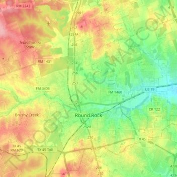
Nome: Mappa topografica Round Rock, altitudine, rilievo.
Luogo: Round Rock, Williamson County, Texas, United States (30.46829 -97.76484 30.59378 -97.59005)
Altitudine media: 242 m
Altitudine minima: 191 m
Altitudine massima: 306 m
Altre mappe topografiche
Clicca su una mappa per visualizzarne la topografia, l'altitudine e il rilievo.
Soil Conservation Service Site 12 Dam
United States > Texas > Williamson County > Type
Altitudine media: 173 m
Soil Conservation Service Site 12 Dam
United States > Texas > Williamson County > Type
Altitudine media: 173 m
Georgetown
United States > Texas > Williamson County > Georgetown
The city is located on the northeastern edge of Texas Hill Country. Portions of Georgetown are located on either side of the Balcones Escarpment, a fault line in which the areas roughly east of IH-35 are flat and characterized by having black, fertile soils of the Blackland Prairie, and the west side of the…
Altitudine media: 228 m
Cedar Park
United States > Texas > Williamson County > Cedar Park > Cedar Park
Altitudine media: 292 m
Round Rock
United States > Texas > Williamson County > Round Rock
The city straddles the Balcones Escarpment, a fault line in which the areas roughly east of Interstate 35 are flat and characterized by having black, fertile soils of the Blackland Prairie, and the west side of the Escarpment, which consists mostly of hilly, karst-like terrain with little topsoil and higher…
Altitudine media: 236 m