
Mappa topografica Mesquite
Mappa interattiva
Clicca sulla mappa per visualizzare l'altitudine.
A proposito di questa mappa
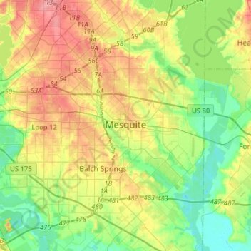
Nome: Mappa topografica Mesquite, altitudine, rilievo.
Luogo: Mesquite, Dallas County, Texas, United States (32.68152 -96.68487 32.84931 -96.42888)
Altitudine media: 142 m
Altitudine minima: 108 m
Altitudine massima: 189 m
Altre mappe topografiche
Clicca su una mappa per visualizzarne la topografia, l'altitudine e il rilievo.
Dallas
United States > Texas > Dallas County > Dallas
Dallas and its surrounding area are mostly flat. The city lies at elevations ranging from 450 to 550 feet (137 to 168 m) above sea level. The western edge of the Austin Chalk Formation, a limestone escarpment (also known as the "White Rock Escarpment"), rises 230 feet (70 m) and runs roughly north–south…
Altitudine media: 158 m