
Mappa topografica Denton
Mappa interattiva
Clicca sulla mappa per visualizzare l'altitudine.
Denton
Denton is located on the northern edge of the Dallas–Fort Worth metropolitan area. These three cities form the area known as the "Golden Triangle of North Texas." According to the United States Census Bureau, the city has a total area of 89.316 square miles (231.33 km2), of which 87.952 square miles (227.79 km2) is land and 1.364 square miles (3.53 km2) is covered by water. The city lies in the northeast edge of the Bend Arch–Fort Worth Basin, which is characterized by flat terrain. Elevation ranges from 500 to 900 feet (150 to 270 m). Part of the city is located atop the Barnett Shale, a geological formation believed to contain large quantities of natural gas. Lewisville Lake, a man-made reservoir, is located 15 miles (24 km) south of the city.
A proposito di questa mappa
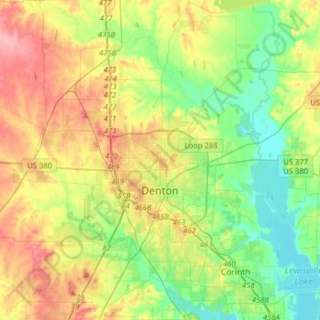
Nome: Mappa topografica Denton, altitudine, rilievo.
Luogo: Denton, Denton County, Texas, United States (33.11749 -97.26651 33.35824 -97.02394)
Altitudine media: 195 m
Altitudine minima: 155 m
Altitudine massima: 255 m
Altre mappe topografiche
Clicca su una mappa per visualizzarne la topografia, l'altitudine e il rilievo.
Lakewood Village
United States > Texas > Denton County > Lakewood Village > Lakewood Village
Altitudine media: 163 m
Lewisville
United States > Texas > Denton County > Lewisville
Lewisville is at 33°2′18″N 97°0′22″W / 33.03833°N 97.00611°W / 33.03833; -97.00611 (33.038316, −97.006232) at an elevation of about 550 feet (170 m). It has a total area of 42.47 square miles (110.0 km2), of which 36.4 sq mi (94 km2) is land. It lies at the southern end of Denton County…
Altitudine media: 174 m