
Mappa topografica Dell City
Mappa interattiva
Clicca sulla mappa per visualizzare l'altitudine.
A proposito di questa mappa
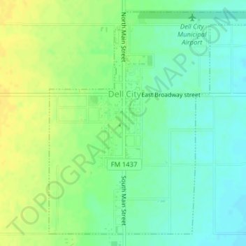
Nome: Mappa topografica Dell City, altitudine, rilievo.
Luogo: Dell City, Hudspeth County, Texas, United States (31.92353 -105.21094 31.94794 -105.18367)
Altitudine media: 1’129 m
Altitudine minima: 1’118 m
Altitudine massima: 1’141 m
Altre mappe topografiche
Clicca su una mappa per visualizzarne la topografia, l'altitudine e il rilievo.
Sierra Blanca
United States > Texas > Hudspeth County
Sierra Blanca is found in Far West Texas, a subdivision of West Texas, and is 4,520 feet (1,380 m) above sea level. The town is part of the Trans-Pecos region within the most mountainous and arid portion of Texas. The town is located in Hudspeth County, which is large and sparsely populated. Sierra Blanca…
Altitudine media: 1’391 m
Sierra Blanca
United States > Texas > Hudspeth County
Sierra Blanca is found in Far West Texas, a subdivision of West Texas, and is located at 31°10′55″N 105°20′27″W / 31.18194°N 105.34083°W / 31.18194; -105.34083 (31.182009, -105.340843) 4,520 feet (1,380 m) above sea level. The town is part of the Trans-Pecos region within the most…
Altitudine media: 1’391 m