
Mappa topografica Bryce Canyon National Park
Mappa interattiva
Clicca sulla mappa per visualizzare l'altitudine.
A proposito di questa mappa
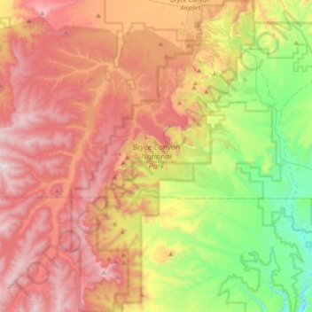
Nome: Mappa topografica Bryce Canyon National Park, altitudine, rilievo.
Altitudine media: 2’259 m
Altitudine minima: 1’640 m
Altitudine massima: 2’902 m
Bryce Canyon National Park (/braɪs/) is an American national park located in southwestern Utah. The major feature of the park is Bryce Canyon, which despite its name, is not a canyon, but a collection of giant natural amphitheaters along the eastern side of the Paunsaugunt Plateau. Bryce is distinctive due to geological structures called hoodoos, formed by frost weathering and stream erosion of the river and lake bed sedimentary rocks. The red, orange, and white colors of the rocks provide spectacular views for park visitors. Bryce Canyon National Park is much smaller and sits at a much higher elevation than nearby Zion National Park. The rim at Bryce varies from 8,000 to 9,000 feet (2,400 to 2,700 m).
Altre mappe topografiche
Clicca su una mappa per visualizzarne la topografia, l'altitudine e il rilievo.
Boulder
United States > Utah > Garfield County
Boulder, Garfield County, Utah, 84716, United States
Altitudine media: 2’115 m
Panguitch
United States > Utah > Garfield County
Panguitch, Garfield County, Utah, 84759, United States
Altitudine media: 2’043 m
Mount Ogden
United States > Utah > Garfield County
Mount Ogden, Garfield County, Utah, United States
Altitudine media: 2’226 m
Escalante
United States > Utah > Garfield County
Escalante, Garfield County, Utah, 84726, United States
Altitudine media: 1’781 m
Henry Mountains
United States > Utah > Garfield County
Henry Mountains, Garfield County, Utah, United States
Altitudine media: 1’936 m
Bryce Canyon
United States > Utah > Garfield County > Tropic
Bryce Canyon, Tropic, Garfield County, Utah, United States
Altitudine media: 2’247 m