
Mappa topografica Brownsville
Mappa interattiva
Clicca sulla mappa per visualizzare l'altitudine.
Brownsville
Soils are mostly of clay to silty clay loam texture, moderately alkaline (pH 8.2) to strongly alkaline (pH 8.5 and with a significant degree of salinity in many places; other types of soils present around the city include Cameron clay and sporadic amounts of Laredo silt loam. Due to Brownsville's proximity to the coast, Lomalta clay is common around the swamp areas of the vicinity. Several parts of the city have a high risk of localized flooding because of flat topography, ubiquitous low-permeability clay soils, and inadequate infrastructure funding.
A proposito di questa mappa
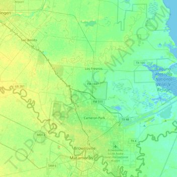
Nome: Mappa topografica Brownsville, altitudine, rilievo.
Luogo: Brownsville, Cameron County, Texas, United States (25.84019 -97.64455 26.21751 -97.27364)
Altitudine media: 9 m
Altitudine minima: -3 m
Altitudine massima: 25 m
Altre mappe topografiche
Clicca su una mappa per visualizzarne la topografia, l'altitudine e il rilievo.
Valle Verde Colonia
United States > Texas > Cameron County > La Feria > Valle Verde Colonia
Altitudine media: 19 m