Mappa topografica Seattle
Mappa interattiva
Clicca sulla mappa per visualizzare l'altitudine.
A proposito di questa mappa
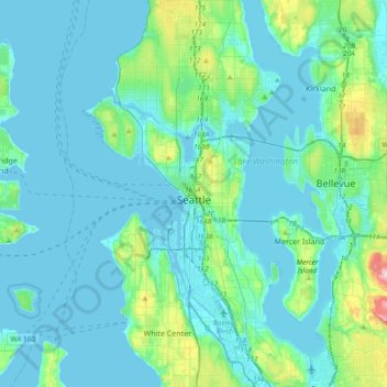
Nome: Mappa topografica Seattle, altitudine, rilievo.
Luogo: Seattle, King County, Washington, United States (47.48100 -122.45970 47.73414 -122.22443)
Altitudine media: 40 m
Altitudine minima: -6 m
Altitudine massima: 320 m
The city itself is hilly, though not uniformly so. Like Rome, the city is said to lie on seven hills; the lists vary but typically include Capitol Hill, First Hill, West Seattle, Beacon Hill, Queen Anne, Magnolia, and the former Denny Hill. The Wallingford, Delridge, Mount Baker, Seward Park, Washington Park, Broadmoor, Madrona, Phinney Ridge, Sunset Hill, Blue Ridge, Broadview, Laurelhurst, Hawthorne Hills, Maple Leaf, and Crown Hill neighborhoods are all located on hills as well. Many of the hilliest areas are near the city center, with Capitol Hill, First Hill, and Beacon Hill collectively constituting something of a ridge along an isthmus between Elliott Bay and Lake Washington. The break in the ridge between First Hill and Beacon Hill is man-made, the result of two of the many regrading projects that reshaped the topography of the city center. The topography of the city center was also changed by the construction of a seawall and the artificial Harbor Island (completed 1909) at the mouth of the city's industrial Duwamish Waterway, the terminus of the Green River. The highest point within city limits is at High Point in West Seattle, which is roughly located near 35th Ave SW and SW Myrtle St. Other notable hills include Crown Hill, View Ridge/Wedgwood/Bryant, Maple Leaf, Phinney Ridge, Mt. Baker Ridge, and Highlands/Carkeek/Bitterlake.
Altre mappe topografiche
Clicca su una mappa per visualizzarne la topografia, l'altitudine e il rilievo.
Bellevue
United States > Washington > King County
Bellevue, King County, Washington, United States
Altitudine media: 66 m
Bothell
United States > Washington > King County
Bothell, King County, Washington, United States
Altitudine media: 68 m
Factoria
United States > Washington > King County > Bellevue
Factoria, Bellevue, King County, Washington, 98006, United States
Altitudine media: 75 m
Azure Lake
United States > Washington > King County
Azure Lake, King County, Washington, United States
Altitudine media: 1’529 m
Sammamish
United States > Washington > King County
Sammamish, King County, Washington, United States
Altitudine media: 97 m
Burien
United States > Washington > King County
Burien, King County, Washington, United States
Altitudine media: 65 m
Maplewood
United States > Washington > King County > Renton
Maplewood, Renton, King County, Washington, 98058, United States
Altitudine media: 102 m
Lake City Memorial Triangle
United States > Washington > King County > Seattle
Lake City Memorial Triangle, 12354, Lake City, Seattle, King County, Washington, 98125, United States
Altitudine media: 61 m
White Center
United States > Washington > King County
White Center, King County, Washington, 98146, United States
Altitudine media: 58 m
Stevens Pass
United States > Washington > King County
Stevens Pass, King County, Washington, United States
Altitudine media: 1’387 m
Grotto
United States > Washington > King County
Grotto, King County, Washington, 98224, United States
Altitudine media: 528 m
Moira Lake
United States > Washington > King County
Moira Lake, King County, Washington, United States
Altitudine media: 1’303 m
Jones Lake
United States > Washington > King County > Black Diamond
Jones Lake, Black Diamond, King County, Washington, United States
Altitudine media: 210 m
Woodinville
United States > Washington > King County
Woodinville, King County, Washington, United States
Altitudine media: 73 m
Annette Lake
United States > Washington > King County
Annette Lake, King County, Washington, United States
Altitudine media: 1’318 m
Renton
United States > Washington > King County
Renton, King County, Washington, United States
Altitudine media: 83 m
Shoreline
United States > Washington > King County
Shoreline, King County, Washington, 98155, United States
Altitudine media: 99 m
Auburn
United States > Washington > King County
Auburn, King County, Washington, United States
Altitudine media: 88 m
Five Mile Lake
United States > Washington > King County > Lakeland South
Five Mile Lake, Lakeland South, King County, Washington, United States
Altitudine media: 115 m
Woodinville
United States > Washington > King County > Woodinville > Woodinville
Woodinville, King County, Washington, 98072, United States
Altitudine media: 80 m
SeaTac
United States > Washington > King County
SeaTac, King County, Washington, United States
Altitudine media: 60 m
Mercer Island
United States > Washington > King County > Mercer Island
Mercer Island, King County, Washington, 98040, United States
Altitudine media: 39 m
Green Lake
United States > Washington > King County > Seattle
Green Lake, Seattle, King County, Washington, 98103, United States
Altitudine media: 75 m
Kirkland
United States > Washington > King County
Kirkland, King County, Washington, United States
Altitudine media: 58 m
Kent
United States > Washington > King County
Kent, King County, Washington, United States
Altitudine media: 87 m
Maple Valley
United States > Washington > King County
Maple Valley, King County, Washington, 98038, United States
Altitudine media: 160 m
Kenmore
United States > Washington > King County
Kenmore, King County, Washington, 98028, United States
Altitudine media: 59 m
Snoqualmie
United States > Washington > King County
Snoqualmie, King County, Washington, 98065, United States
Altitudine media: 213 m
Issaquah
United States > Washington > King County
Issaquah, King County, Washington, United States
Altitudine media: 164 m
Redmond
United States > Washington > King County
Redmond, King County, Washington, United States
Altitudine media: 72 m
Federal Way
United States > Washington > King County
Federal Way, King County, Washington, United States
Altitudine media: 81 m
Skykomish
United States > Washington > King County
Skykomish, King County, Washington, United States
Altitudine media: 441 m