
Mappa topografica Dnieper River
Mappa interattiva
Clicca sulla mappa per visualizzare l'altitudine.
Dnieper River
The source of the Dnieper is the sedge bogs (Akseninsky Mokh) of the Valdai Hills in central Russia, at an elevation of 220 m (720 ft). For 115 km (71 mi) of its length, it serves as the border between Belarus and Ukraine. Its estuary, or liman, used to be defended by the strong fortress of Ochakiv.
A proposito di questa mappa
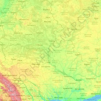
Nome: Mappa topografica Dnieper River, altitudine, rilievo.
Luogo: Dnieper River, Belarus (46.48514 30.02091 55.87170 35.19678)
Altitudine media: 194 m
Altitudine minima: -8 m
Altitudine massima: 1’978 m
Altre mappe topografiche
Clicca su una mappa per visualizzarne la topografia, l'altitudine e il rilievo.
Dnieper
Belarus > Homyel Region > Brahin District > Новаялчанскі сельскі Савет
The source of the Dnieper is the sedge bogs (Akseninsky Mokh) of the Valdai Hills in central Russia, at an elevation of 220 m (720 ft). For 115 km (71 mi) of its length, it serves as the border between Belarus and Ukraine. Its estuary, or liman, used to be defended by the strong fortress of Ochakiv.
Altitudine media: 106 m
Highest point of the Kapyl hill chain
Belarus > Minsk Region > Kapyl District > Пацейкаўскі сельскі Савет
Altitudine media: 227 m
Dnieper
Belarus > Homyel Region > Brahin District > Новаялчанскі сельскі Савет
The source of the Dnieper is the sedge bogs (Akseninsky Mokh) of the Valdai Hills in central Russia, at an elevation of 220 m (720 ft). For 115 km (71 mi) of its length, it serves as the border between Belarus and Ukraine. Its estuary, or liman, used to be defended by the strong fortress of Ochakiv.
Altitudine media: 106 m
озеро Ёди
Belarus > Hrodna Region > Astravyets District > Михалишковский сельский Совет
Altitudine media: 140 m