
Fai una donazione
Equipaggiati per la tua prossima avventura:
In qualità di Affiliato Amazon, questo sito riceve una commissione sugli acquisti idonei, senza costi aggiuntivi per l’utente.
Mappa topografica Aachen
Clicca sulla mappa per visualizzare l'altitudine.
Fai una donazione
Equipaggiati per la tua prossima avventura:
In qualità di Affiliato Amazon, questo sito riceve una commissione sugli acquisti idonei, senza costi aggiuntivi per l’utente.
Aachen
Aachen is located at the northern foothills of the High Fens and the Eifel Mountains. It sits on the Wurm River, a tributary of the Rur, and together with Mönchengladbach, it is the only larger German city in the drainage basin of the Meuse. It is the westernmost larger city in Germany, lying approximately 61 km (38 mi) west of Cologne and Bonn, directly bordering Belgium in the southwest, and the Netherlands in the northwest. The Vaalserberg, highest elevation in the European Netherlands, with the three-country point on its summit, is located within Aachen's city limits. The city lies in the Meuse–Rhine Euroregion and is the seat of the district of Aachen (Städteregion Aachen).
Fai una donazione
Equipaggiati per la tua prossima avventura:
In qualità di Affiliato Amazon, questo sito riceve una commissione sugli acquisti idonei, senza costi aggiuntivi per l’utente.
A proposito di questa mappa
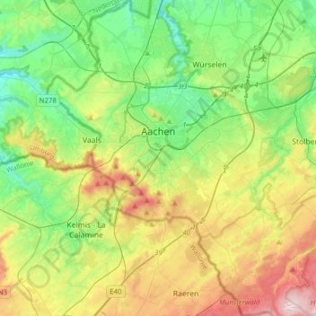
Nome: Mappa topografica Aachen, altitudine, rilievo.
Luogo: Aachen, Aachen (district), North Rhine-Westphalia, Germany (50.66214 5.97487 50.85724 6.21811)
Altitudine media: 225 m
Altitudine minima: 103 m
Altitudine massima: 456 m
Fai una donazione
Equipaggiati per la tua prossima avventura:
In qualità di Affiliato Amazon, questo sito riceve una commissione sugli acquisti idonei, senza costi aggiuntivi per l’utente.
Altre mappe topografiche
Clicca su una mappa per visualizzarne la topografia, l'altitudine e il rilievo.