Mappa topografica Orkney Islands
Mappa interattiva
Clicca sulla mappa per visualizzare l'altitudine.
A proposito di questa mappa
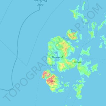
Nome: Mappa topografica Orkney Islands, altitudine, rilievo.
Luogo: Orkney Islands, Scotland, United Kingdom (58.68595 -3.43587 59.39272 -2.37048)
Altitudine media: 9 m
Altitudine minima: -1 m
Altitudine massima: 468 m
The southern group of islands surrounds Scapa Flow. Hoy is the second largest of the Orkney Isles and Ward Hill at its northern end is the highest elevation in the archipelago. The Old Man of Hoy is a well-known seastack. Burray lies to the east of Scapa Flow and is linked by causeway to South Ronaldsay, which hosts the cultural events, the Festival of the Horse and the Boys' Ploughing Match on the third Saturday in August. It is also the location of the Neolithic Tomb of the Eagles. Graemsay and Flotta are both linked by ferry to the Mainland and Hoy, and the latter is known for its large oil terminal. South Walls has a 19th-century Martello tower and is connected to Hoy by the Ayre. South Ronaldsay, Burray, Glimps Holm, and Lamb Holm are connected by road to the Mainland by the Churchill Barriers.
Altre mappe topografiche
Clicca su una mappa per visualizzarne la topografia, l'altitudine e il rilievo.
Rendall
United Kingdom > Scotland > Orkney Islands
Rendall, Orkney Islands, Scotland, KW17 2NZ, United Kingdom
Altitudine media: 42 m